 |
| Section of an ideal POW Camp organisation |
 |
| Map - Oflag V1B - 'Australian War Memorial' |
Much has been written since the Second World War around MI9
and MIS – X concealing maps and other escape aids in innocent everyday items
e.g. shaving brushes, pencil clips, monopoly games, gramophone records, playing
cards etc. These were sent to prisoner of war camps in boxes and packages under
the guise of various welfare and charity organisations for prisoners. (See
previous posts).
It was a few years before this operation kicked
into full swing, and whilst these aids would prove invaluable in escape
attempts, the items would only help a few of the thousands of prisoners. Most
maps were produced in the camp by the prisoners themselves under difficult
conditions. No drawing or printing materials were available as these were
strictly forbidden, so considerable levels of creativity and underhand
practices had to be applied to obtain or produce them.
 |
| Eichstatt - Oflag V11B - 'Australian War Memorial |
Intelligence and security were crucial in the operation. In an
ideal camp organisation, the Camp Intelligence Officer would head the map operation
and coordinate intelligence, whilst ‘X’ looked after security. As outlined in
previous posts, in some camps ‘X’ handled intelligence in conjunction with the
cogs and machinery of actual escape work (including map making), leaving security
to the SO (Security Officer).
A camp might already have maps smuggled in via MI9/MIS- X
parcels or obtained via illicit means. These could form the master copies from
which the map makers worked, though they were insufficient in number and often
lacking local detail. Current intelligence
on the area around the camp was vital, so it could be translated on to maps as
every second counted during the initial stages of an escape.
Details on the surrounding area were obtained from internal
and external sources. New prisoners
arriving in the camp plus those recently recaptured and returned were debriefed
for snippets of intelligence about the geography and terrain, the quietest
pathways away from the area, useful short cuts or seldom used routes, railways,
new roads, and landmarks which might aid navigation. This information also came
from prisoners who had been on working parties outside the camp or German
guards and ferrets, who might unwittingly reveal something in casual
conversation. Useful sources were German camp personnel who had been previously
compromised by accepting bribes of luxuries such as coffee or chocolate. ‘Tame
goons’ as the prisoners referred to them were often targeted. All information
had to be collated and filtered through to the map makers. In a model
organisation this would be via the Camp Intelligence officer (CIO).
 |
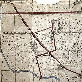
| Map Hanover to Kassel - Oflag 79 - 'Australian War Memorial' |
Englishman Philip Evans was serving as a captain in the Royal Artillery when he was taken prisoner at Tobruk in 1942. A printer by trade, he saw
the possibility of making printing plates from tiles which came from a bombed
out building in the camp. The detail on the map could be drawn by hand on to
the plates, with ink being made from melted margarine mixed with pitch scraped
from a walkway. The printing press came from floorboards, and an ink roller from a
window bar covered with leather.
 |
| Map drawn by Philip Evans - copyright British Library Board |
Because of the numbers of maps required, individual tracing map
by map was too slow, so Plunkett managed to obtain some invalid jellies through
a German in the hospital block in the kommandantur.
He cut them up, soaked them in hot water, and squeezed them through a handkerchief,
tasting the fruity solution that ran out until it was no longer sweet. The sugar
had effectively been extracted from the gelatine which was still left in the
handkerchief. He melted the solution, pouring it into flat trays made from old
food tins. Once it was set Plunkett had a basic but effective mimeograph
(stencil).
He used ink made from the crushed lead of indelible pencils
to draw the master copy of his maps. These were supplied by suitably
compromised ‘tame’ Germans who had been ‘approached.’ After pressing the drawn
map on the mimeograph, Plunkett was able to print off hundreds of copies.
©Keith Morley
THIS BLOG claims no credit for any images posted on this
site unless otherwise noted. Images on this blog are copyright to its
respectful owners. If there is an image appearing on this blog that belongs to
you and do not wish for it appear on this site, please message me with a link
to said image and it will be promptly removed
Sources
The Great Escape – Paul Brickhill
Personal notes
Next week - 'X' and Camp Security
How ingenuous. I do wonder if people would be able to survive in similar circumstances these days without their technology. I think the younger generation are becoming far too self reliant on their modern devices.
ReplyDeleteCouldn't agree more Sally.
ReplyDeleteThese stories of human endeavour have been fascinating posts by Keith. How inventive POWs and others were in those times. The large companies then were also involved heavily in helping the combined war effort. Waddington PLC, the printing company best known for its games including Monopoly, was involved in a most unusual venture during the Second World War: printing maps on silk, rayon and tissue paper for military use and smuggling some of them to prisoners of war. Waddington already possessed the technology to print on cloth and made a variety of board games, packs of cards and so forth that could sent to the camps. They began by printing silk maps for supply to air crews, both British and American, and went on to conceal maps inside Monopoly boards, chess sets and packs of cards which could be sent into the prison camps. The whole business of making the maps was shrouded in secrecy. Over 35,000 British and other Allied troops imprisoned or cut off behind enemy lines did manage to make their way to Allied territory before the end of the war. About half of these would have had a silk map with them. In many of these cases their maps and compasses, and other escape aids, must have saved their lives.
ReplyDelete“We're all pilgrims on the same journey - but some pilgrims have better road maps.”
Nelson DeMille
I received a very interesting mail from Mark Radcliffe-Evans which I have copied here. I have made the correction to the post and if anyone is interested in the project which Mark is working on and would like further information, I can put them in contact with him.
ReplyDelete'The Philip Evans you refer to was my father. Not Australian, but born in Liverpool in 1917, and served as a captain in the Royal Artillery. He was captured at Tobruk in 1942, held first at Chieti in Italy, then in Silesia, probably at Stalag VIII-B, then finally at Oflag 79, Brunswick-Querum. He died in 1992, and I have a number of sets of his maps, and donated the one you have illustrated to the British Museum in 1997 as part of a set of 4. I have 2 remaining sets of the 4 and an original litho plate in my possession, which he bought back in a goat skin German dispatch rider's bag when he was liberated in April 1945. He wrote an article about the press and maps under the title The Brunswick Printers for the Printing Review in 1951. I am currently in the process of arranging to have this reprinted and republished as a letterpress printed limited edition in conjunction with Juniper Press, Liverpool, with the possibility of a facsimile edition if there is enough interest. I expect a publication date late 2015. If you or anyone reading this is interested in an update and further information, feel free to contact me.'
I recently retweeted the link to this post via Twitter. Following on from this and the 2014 comments above, Mark has been in contact to advise that his book is now in print and it is available to purchase online. 3 years work has gone into the project and a visit to the link below is recommended. https://thebrunswickprinters.com/
ReplyDelete